Land Records ಮೂಲಕ ನಿಮ್ಮ ತಂದೆ ಹಾಗು ಅಜ್ಜನ ಆಸ್ತಿ ಬಗ್ಗೆ ತಿಳಿದುಕೊಳ್ಳಬಹುದು ಇಲ್ಲಿದೆ ನೋಡಿ Karnataka App
Karnataka Land Records
Karnataka’s land records system is a landmark initiative by the state government that has transformed the way land and property information is recorded, maintained, and accessed. This extensive report explores every facet of the system—from its historical evolution and technological infrastructure to the benefits it brings to citizens and the challenges it faces. The discussion is segmented into thematic sections that cover the origins, current functionalities, user engagement, legal and administrative frameworks, case studies, and future directions for the system. By the end of this report, readers will have gained a thorough understanding of how the system operates and why it is considered a model of digital governance in land management.
1. Historical Context and Evolution of Land Records in Karnataka
1.1 Pre-Digital Era Land Records
Before the advent of modern digital technologies, Karnataka, like many regions in India, maintained its land records using traditional, manual methods. Historical documents, handwritten registers, and physical maps were the norm. These records were kept in revenue offices spread throughout the state, with land records being updated through a largely paper-based system. Key characteristics of the pre-digital era included:
- Manual Record Keeping: Land records were maintained in large registers and bound volumes. Updates were made by revenue officials using handwritten notations.
- Geographical Dispersion: Each district or taluk maintained its own records, meaning that a complete picture of land ownership could be difficult to compile without visiting multiple offices.
- Limited Accessibility: Access to records was generally confined to government officials and those who physically visited the revenue offices. This created delays and inefficiencies in legal and administrative processes.
- Vulnerability to Errors and Fraud: Manual record-keeping was prone to human error, and in some cases, records could be tampered with or lost.
These limitations spurred calls for a more modern, integrated approach that could address the challenges of accuracy, transparency, and accessibility.
1.2 The Shift Toward Digital Record Keeping
The need for a reform became apparent as Karnataka experienced rapid urbanization, an increase in real estate transactions, and a growing demand for transparency in property ownership. Digital transformation in the realm of land records began with pilot projects aimed at automating data entry, digitizing archival documents, and creating a centralized database that could be accessed by both government officials and the public. Key milestones in this evolution include:
- Initiation of Digitization Projects: In the early 2000s, the state government started initiatives to digitize land records. This involved scanning historical documents and converting paper-based data into digital formats.
- Establishment of the Bhoomi Portal: The Bhoomi portal became the flagship platform for Karnataka’s land records. Launched as a comprehensive resource, it allowed citizens to access their land records online, view maps, check mutation records, and much more.
- Adoption of IT Infrastructure: The integration of IT systems meant that records could be updated in real time, and a centralized database ensured consistency across regions.
- Regulatory Reforms: Legal frameworks were updated to support digital records, including amendments to rules governing land transactions and the admissibility of electronic records in courts.
This transition was marked by significant government investment, the involvement of IT experts, and collaboration between various state departments to ensure a smooth implementation process.
1.3 Historical Impact on Governance and Rural Development
The modernization of land records brought about transformational changes in governance and rural development. Improved record keeping meant that property disputes could be resolved more quickly, and the government could more effectively collect land revenue. Rural areas, in particular, benefited from greater access to digital services that reduced the need for long-distance travel to administrative centers. The historical context thus set the stage for a system that not only modernized administrative processes but also supported the socio-economic development of the region.
2. Overview of the Bhoomi Portal
2.1 What is the Bhoomi Portal?
The Bhoomi portal is the official online interface provided by the Karnataka government for accessing land records. It serves as a one-stop digital platform that integrates various functions and services related to land management. Citizens, government officials, legal practitioners, and other stakeholders can use the portal to access verified, up-to-date land information. The portal’s design prioritizes user-friendliness and accessibility, ensuring that even those with minimal computer literacy can navigate its features.
2.2 Key Features of the Portal
2.2.1 Land Ownership Details
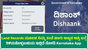
One of the cornerstone functionalities of the Bhoomi portal is the ability to retrieve detailed information on land ownership. Users can input parameters such as district, taluk, hobli, village, and survey numbers to obtain:
- Name of the Land Owner: The identity of the registered owner(s) of a piece of land.
- Ownership History: Historical data detailing previous owners and any changes in ownership over time.
- Additional Metadata: Information on the land’s classification, such as agricultural or residential, and any associated encumbrances.
2.2.2 Mutation Records
Mutation refers to the process of updating the land records following any transfer of ownership, inheritance, or sale. The portal allows users to:
- Apply for Mutation: Initiate the process for updating records after a transaction.
- Check Status: Monitor the progress of an ongoing mutation request.
- View Past Mutations: Access historical mutation data for reference or legal purposes.
2.2.3 Survey and Map Access
The Bhoomi portal includes a feature for accessing detailed survey maps. These maps are essential for understanding the physical boundaries and dimensions of a property. They typically include:
- Survey Numbers: Each plot is assigned a unique survey number that corresponds to its physical boundaries.
- Geographical Information: Detailed maps that display the land’s topography, neighboring plots, and other geographical markers.
- Measurement Data: Information on the dimensions and area of the property, often derived from professional surveys.
2.2.4 Revenue and Tax Records
Accurate revenue records are critical for property taxation and other fiscal purposes. The portal provides access to:
- Land Revenue Data: Details of the land revenue associated with a property, including historical and current figures.
- Taxation Records: Information on any taxes levied on the land, including payment history and dues.
- Assessment Details: Data related to how the land is assessed for taxation, which can be useful for resolving disputes or planning property transactions.
2.3 User Interface and Navigation
The Bhoomi portal is designed with the end-user in mind. Its intuitive interface is segmented into several key sections:
- Dashboard: A central hub that displays user-specific information, notifications, and shortcuts to common services.
- Search Tools: Simple forms and filters that allow users to search for land records using various parameters.
- Help and Support: Integrated help features that guide users through common processes, such as applying for mutation or retrieving maps.
- Language Options: The portal supports multiple languages, including Kannada and English, ensuring that a wide range of users can access information comfortably.
2.4 Accessibility and Security Measures
Given the sensitivity of land records, the Bhoomi portal has implemented robust security measures to ensure that data is both accurate and secure. These measures include:
- User Authentication: Secure login mechanisms that require verification before granting access to sensitive data.
- Data Encryption: Advanced encryption protocols that protect data during transmission and storage.
- Audit Trails: Comprehensive logging of all transactions and access events, enabling the detection of unauthorized activity.
- Periodic Updates: Regular software updates and security audits to address vulnerabilities and improve overall system performance.
3. Detailed Functionalities and Service Modules
3.1 Viewing and Verifying Land Ownership
3.1.1 Accessing Ownership Details
The primary function of the Bhoomi portal is to allow users to verify who holds title to a given piece of land. This involves:
- Search by Location: Users can enter the district, taluk, hobli, and village names along with survey numbers to find the relevant records.
- Display of Ownership Data: Once a record is located, the portal displays the name(s) of the registered owner(s), along with additional details such as relationship links (in cases of joint ownership or inheritance).
3.1.2 Benefits for Stakeholders
The ability to verify ownership online has several benefits:
- Transparency: Reduces the scope for disputes over ownership by providing clear, publicly accessible records.
- Efficiency: Eliminates the need for physical visits to government offices, thereby saving time for both citizens and officials.
- Legal Assurance: Provides legal backing by ensuring that the records presented are officially maintained and updated.
3.2 The Mutation Process
3.2.1 Understanding Mutation
Mutation is a critical administrative process that involves updating the land records after a transfer of ownership. It ensures that the government records reflect the current status of property ownership. Key aspects of mutation include:
- Document Submission: Landowners are required to submit relevant legal documents that prove the change in ownership.
- Verification Process: The submitted documents are verified by revenue officials.
- Record Update: Once verification is complete, the land records are updated to reflect the new ownership.
- Notification: Both the previous and new owners are notified about the update.
3.2.2 Online Mutation Application
The Bhoomi portal streamlines the mutation process by allowing users to submit applications online. This process generally includes:
- Filling in the Application Form: Users input details about the property and the nature of the transaction.
- Uploading Supporting Documents: Digital copies of sale deeds, inheritance certificates, or other relevant legal documents are uploaded for verification.
- Payment of Fees: Any applicable fees can be paid online using integrated payment gateways.
- Tracking the Application: Users can track the progress of their mutation request through the portal’s status update feature.
3.3 Accessing Survey Maps and Measurement Data
3.3.1 Importance of Accurate Survey Data
Accurate survey data is indispensable for delineating property boundaries, planning construction projects, and resolving disputes. Survey maps provided through the Bhoomi portal offer detailed insights into the physical aspects of the land. Features include:
- Scale and Precision: The maps are created using professional surveying techniques that ensure precision in depicting boundaries.
- Integration with GIS: Geographic Information System (GIS) technology is often integrated to provide additional layers of information such as terrain, water bodies, and nearby infrastructures.
- Historical Comparisons: In some cases, the portal offers access to historical survey data, which can be useful for tracking changes over time.
3.3.2 User Interaction with Maps
The survey maps on the Bhoomi portal are interactive, allowing users to:
- Zoom In and Out: Examine properties at various scales to gain a detailed understanding of their dimensions.
- Overlay Data: Superimpose other data layers such as land use patterns, road networks, and utility lines.
- Download and Print: Options are available to download the maps for offline use or to print hard copies for official or personal records.
3.4 Revenue and Taxation Records
3.4.1 Detailed Revenue Information
Revenue records are a vital component of the land records system, ensuring that property taxation is based on accurate and current data. Through the Bhoomi portal, users can:
- View Revenue History: Access records that detail historical revenue collections, changes in tax rates, and adjustments made over time.
- Assess Current Liabilities: Understand the current tax liabilities on a property, including any dues or pending payments.
- Review Payment History: Check past payment records, which can be important for resolving disputes with tax authorities.
3.4.2 Integration with Financial Systems
The integration of revenue records with financial systems means that:
- Automated Calculations: Tax assessments are updated automatically based on changes in the land records, reducing manual errors.
- Real-Time Updates: Changes in ownership, mutations, or land use classifications are reflected immediately in the revenue records.
- Streamlined Payments: Integrated online payment systems allow users to clear tax dues conveniently, thereby ensuring timely revenue collection for the state.
4. Administrative and Legal Framework
4.1 Legislative Background
The modernization of land records in Karnataka has been supported by a robust legal framework that ensures the legitimacy and reliability of digital records. Key legislative measures include:
- Amendments to Land Revenue Laws: Over the years, various amendments have been made to existing land revenue laws to accommodate digital record keeping. These amendments address issues such as the admissibility of electronic documents and the legal status of digital signatures.
- Regulations Governing Mutation: Specific guidelines have been introduced to standardize the mutation process. These regulations stipulate the documentation required, timelines for processing, and the responsibilities of both the landowner and the revenue officials.
- Data Protection and Privacy Laws: With the digitalization of records, safeguarding personal information has become paramount. Karnataka has enacted policies that ensure the privacy and security of land record data, conforming to national standards on data protection.
4.2 Role of Revenue Departments and Local Bodies
The successful implementation of the digital land records system relies heavily on the coordinated efforts of various government bodies. Key players include:
- District and Taluk Offices: These local bodies are responsible for maintaining regional records and ensuring that data is accurately uploaded to the central system.
- Revenue Departments: At the state level, revenue departments oversee the overall system, provide training to local officials, and conduct periodic audits to maintain data integrity.
- Judicial Oversight: Courts occasionally reference the Bhoomi portal for resolving land disputes, lending legal weight to the digital records and ensuring that they are recognized in legal proceedings.
4.3 Standard Operating Procedures (SOPs)
To ensure uniformity and efficiency, the state government has established a set of Standard Operating Procedures (SOPs) that govern every aspect of the land records system:
- Data Entry Protocols: Detailed guidelines are provided to revenue officials on how to enter and verify data, including quality control measures to prevent errors.
- Mutation Guidelines: Clear procedures dictate how mutation requests are processed, from initial submission to final approval.
- Audit and Compliance: Regular audits are mandated to check for discrepancies, ensuring that any errors are identified and corrected promptly.
- Dispute Resolution Mechanisms: A structured framework is in place for handling disputes, with defined timelines and protocols to ensure that conflicts are resolved efficiently.
5. Technological Infrastructure and Innovations
5.1 Database Management and Storage
At the heart of the Bhoomi portal lies a sophisticated database management system that stores vast amounts of land-related data. Key elements include:
- Centralized Data Repository: All land records, survey maps, and revenue information are stored in a single, centralized database. This integration ensures consistency and allows for real-time updates across all user interfaces.
- Data Redundancy and Backup: To prevent data loss due to technical failures, multiple backup systems are in place. Regular data replication and off-site storage ensure that records remain secure even in the event of a system malfunction.
- Scalability: As the number of users and records increases, the system is designed to scale, ensuring that performance remains robust and responsive.
5.2 Software and Web Technologies
The Bhoomi portal leverages a range of modern software and web technologies to deliver its services:
- User-Friendly Web Interface: The portal is built using responsive web design principles, ensuring that it is accessible from desktops, laptops, tablets, and smartphones.
- Integrated Search Engines: Advanced search algorithms enable users to quickly locate records using parameters such as location, survey numbers, or owner details.
- Interactive Map Technologies: GIS and other mapping technologies are employed to create interactive survey maps that allow users to explore property boundaries in detail.
- Security Frameworks: The use of secure protocols such as HTTPS, along with multi-factor authentication, ensures that user data is protected during both transmission and storage.
5.3 Data Integration and Interoperability
One of the major strengths of Karnataka’s land records system is its ability to integrate data from various sources:
- Linking with National Databases: The system is often linked with other national-level databases, such as those maintained by the Ministry of Rural Development or the Department of Land Resources, enabling cross-verification of records.
- Interdepartmental Data Sharing: Various state departments share data with the Bhoomi portal. For instance, updates on land use from the urban development department can prompt corresponding updates in land records.
- Real-Time Synchronization: Updates made at the local level are synchronized with the central database in real time, ensuring that users always have access to the most current information.
5.4 Mobile Applications and Future Technologies
In recognition of the widespread use of mobile devices, efforts have been made to ensure that Karnataka’s land records are accessible on the go:
- Mobile-Friendly Web Portals: The Bhoomi portal is optimized for mobile browsers, allowing users to access records and apply for mutations using their smartphones.
- Dedicated Mobile Applications: Plans for dedicated mobile applications are underway, which will offer additional features such as push notifications for status updates, offline data access, and location-based services.
- Emerging Technologies: The government is exploring the use of blockchain for added security and transparency, ensuring that once a record is updated, it cannot be altered without proper authorization. Such innovations are expected to further enhance the integrity of the land records system.
6. Socio-Economic Impacts of Digital Land Records
6.1 Enhancing Transparency and Reducing Fraud
A significant advantage of the digitalization of land records is the transparency it brings to the process of property transactions:
- Reduction of Fraud: With records maintained centrally and accessible online, the potential for fraudulent alterations is significantly reduced.
- Improved Accountability: Revenue officials are held accountable for data entry, as discrepancies can be easily detected and traced back to their source.
- Empowered Citizens: Homebuyers and landowners can independently verify property details, reducing reliance on intermediaries and minimizing the risk of fraud.
6.2 Economic Efficiency and Cost Savings
The modernization of land records has also resulted in considerable economic benefits:
- Lower Transaction Costs: By eliminating the need for physical visits to government offices, the system saves both time and money for citizens.
- Streamlined Revenue Collection: Automated tax assessments and online payment systems have made the process of revenue collection more efficient, leading to better fiscal management by the state.
- Boost to the Real Estate Market: Reliable land records have instilled confidence in the real estate market, making transactions smoother and more secure. This, in turn, has contributed to economic growth and urban development.
6.3 Empowering Rural and Urban Communities
The benefits of the digital land records system extend to both rural and urban areas:
- Rural Development: Farmers and rural residents can now access records without the need to travel to distant revenue offices. This improves access to government schemes, subsidies, and legal support related to land issues.
- Urban Planning: City planners and developers have access to accurate land use data, which is crucial for urban development, zoning, and infrastructure planning.
- Legal Empowerment: Ready access to official records helps resolve disputes more quickly and ensures that citizens are aware of their rights regarding land ownership and usage.
6.4 Social Justice and Inclusivity
The digital system has also played a role in promoting social justice:
- Inclusion of Marginalized Communities: The increased accessibility of land records helps marginalized groups, including women and lower-income communities, assert their property rights.
- Transparency in Land Distribution: The system minimizes opportunities for corrupt practices in land allocation, thereby promoting equitable access to land resources.
- Educational Outreach: Various training programs and workshops are conducted by local bodies to educate citizens on how to access and use the digital system, fostering greater public engagement.
7. Administrative Challenges and Limitations
Despite its many advantages, Karnataka’s land records system faces several challenges:
7.1 Data Quality and Consistency Issues
- Legacy Data Problems: Historical records digitized from paper documents may contain errors, omissions, or inconsistencies that are difficult to rectify.
- Data Entry Errors: Human errors during data entry can lead to discrepancies that require manual audits and corrections.
- Fragmented Records: While many records have been centralized, some data remains fragmented across different offices, necessitating further integration efforts.
7.2 Technological Limitations and Infrastructure
- Connectivity Issues: In remote areas, limited internet connectivity can hamper access to the digital portal, thereby affecting rural users.
- System Downtime: Like any digital system, the Bhoomi portal is occasionally subject to technical glitches and downtime, which can delay important transactions.
- Hardware Constraints: Some local offices may lack the necessary hardware or trained personnel to update records efficiently, leading to bottlenecks.
7.3 User Literacy and Accessibility
- Digital Literacy: Not all citizens, particularly in rural areas, are fully comfortable with digital tools. Efforts are ongoing to improve digital literacy through community training programs.
- Language Barriers: Although the portal supports multiple languages, there may still be challenges for users who are not proficient in the languages offered, which could impede their ability to navigate the system effectively.
7.4 Legal and Bureaucratic Hurdles
- Bureaucratic Resistance: In some instances, entrenched bureaucratic practices may slow down the process of fully transitioning to a digital system.
- Legal Disputes: Discrepancies between digital records and older, paper-based documents can lead to legal disputes that require judicial intervention.
- Policy Implementation: The rapid pace of technological change sometimes outstrips the implementation of corresponding legal reforms, leading to gaps in policy that need to be addressed.
8. Case Studies and Practical Applications
8.1 Successful Implementation in Urban Areas
Urban centers in Karnataka, such as Bangalore, have reaped significant benefits from the Bhoomi portal:
- Streamlined Property Transactions: In metropolitan areas, the ease of verifying land records online has accelerated property transactions, boosting the real estate market.
- Urban Planning and Development: City authorities use digital records to plan infrastructure projects, allocate land for public use, and monitor urban growth.
- Reduction in Disputes: Ready access to verified records has led to a decline in property disputes, contributing to a more stable and predictable real estate environment.
8.2 Transforming Rural Land Management
Rural areas have experienced transformative changes due to the digitalization of land records:
- Empowerment through Transparency: Farmers and rural residents now have the ability to independently verify land records, which has reduced instances of fraud and dispute.
- Integration with Government Schemes: The digital records help in the seamless implementation of government schemes related to land, such as agricultural subsidies and rural development programs.
- Community Engagement: Local governments have leveraged the portal to engage communities in land management decisions, leading to more participatory governance.
8.3 Addressing Legal Disputes with Digital Evidence
Several legal cases in Karnataka have highlighted the importance of accurate digital land records:
- Judicial Recognition: Courts have increasingly relied on data from the Bhoomi portal to adjudicate property disputes, recognizing it as a reliable source of evidence.
- Case Resolution: In instances where discrepancies arose between physical and digital records, the availability of audit trails and detailed mutation histories helped resolve disputes swiftly.
- Precedent for Future Cases: These legal precedents underscore the reliability of digital records and set a benchmark for future cases involving land ownership disputes.
8.4 Integration with Other Government Systems
A key strength of Karnataka’s system is its ability to integrate with other government databases:
- Linkages with Municipal Records: Urban local bodies integrate digital land records with municipal planning and building permits, ensuring a holistic view of property data.
- Collaboration with National Agencies: Efforts are underway to integrate the Bhoomi portal with national land records systems, thereby enhancing data reliability and broadening the scope of available information.
- Cross-Verification Mechanisms: Integrated data systems allow for cross-verification, which enhances the overall accuracy and reliability of the records.
9. Future Directions and Prospects
9.1 Enhancing Technological Capabilities
Looking ahead, the Karnataka government is focusing on further enhancing the technological underpinnings of its land records system:
- Adoption of Blockchain: Blockchain technology is being explored as a means to further secure records against tampering. This would create an immutable ledger of transactions that is both transparent and resistant to fraud.
- Artificial Intelligence and Machine Learning: AI-driven analytics can help in detecting anomalies in the data, predicting areas where errors may occur, and automating routine tasks such as data entry and verification.
- Cloud Computing: Migrating more aspects of the system to cloud-based infrastructure could provide better scalability, enhanced security, and easier access for remote users.
9.2 Policy Reforms and Legal Innovations
As technology evolves, so too must the legal frameworks that govern land records:
- Updating Legal Provisions: Laws related to digital records are continually being revised to address emerging challenges and to ensure that digital documents are recognized in all legal proceedings.
- Streamlining Bureaucratic Processes: Policy reforms aimed at reducing bureaucratic red tape can help ensure that updates to land records are processed more quickly and efficiently.
- Enhanced Data Protection Laws: With increasing reliance on digital records, policies that focus on data protection and privacy will be further strengthened, aligning with global standards.
9.3 Community Outreach and Digital Literacy Programs
For the system to be truly effective, widespread adoption and understanding are key:
- Training Initiatives: The government and local bodies are organizing training programs and workshops aimed at increasing digital literacy among citizens, particularly in rural areas.
- Localized Support Centers: Establishing support centers in remote areas can help citizens access services and receive real-time assistance when using the portal.
- Awareness Campaigns: Public awareness campaigns are being launched to educate citizens about the benefits of the digital system, how to navigate it, and the legal protections it offers.
9.4 Future Applications and Expansion
The future of digital land records in Karnataka could include several new functionalities:
- Integration with Land Use Planning: Beyond basic record keeping, future iterations of the system might incorporate modules for land use planning, helping local governments manage urban sprawl and environmental concerns.
- Real Estate Market Analytics: Data from the Bhoomi portal can be analyzed to gain insights into real estate trends, property valuations, and market dynamics, supporting both policymakers and investors.
- Citizen Feedback Mechanisms: Future updates could include mechanisms for citizens to provide feedback on discrepancies or suggest improvements, creating a more participatory and responsive system.
- Interstate Data Sharing: As other states move toward digital systems, there could be opportunities for standardized data sharing across regions, enhancing the overall transparency and efficiency of land management in India.
10. Comparative Analysis: Karnataka Versus Other States
10.1 Benchmarking Against Global Standards
Karnataka’s land records system is often compared with similar systems in other regions both within India and internationally. Key points of comparison include:
- Efficiency and Transparency: Many advanced economies have long embraced digital record keeping. Karnataka’s system is seen as a significant step in this direction, particularly in terms of transparency and ease of access.
- User Experience: The user-friendly interface of the Bhoomi portal is comparable to global standards, making it accessible even to those who are not technologically savvy.
- Legal and Regulatory Frameworks: Compared to some regions where digital records are still not fully recognized in courts, Karnataka’s robust legal backing provides a strong foundation for its digital system.
10.2 Lessons Learned from Other Jurisdictions
Other states and countries have implemented similar systems, and Karnataka has benefited from these experiences:
- Adoption of Best Practices: Learning from global case studies, Karnataka has incorporated features such as real-time updates, audit trails, and mobile accessibility to enhance its system.
- Overcoming Resistance: Similar challenges, such as bureaucratic inertia and technical glitches, have been faced by other regions. Karnataka’s proactive approach in training and infrastructure investment has helped mitigate these issues.
- Continuous Improvement: Many successful digital land records systems operate on a continuous improvement model, regularly updating their software and processes. Karnataka’s iterative approach to development ensures that the system remains at the cutting edge of digital governance.
11. Impact on Governance and Public Administration
11.1 Improved Accountability and Transparency
Digital land records have significantly enhanced the accountability of public administration:
- Auditability: With every transaction recorded digitally, audit trails can be maintained with precision, ensuring that any discrepancies can be traced back to their source.
- Public Scrutiny: Easy access to land records enables citizens and civil society organizations to monitor government actions, leading to increased accountability and reduced corruption.
- Standardization of Processes: The digitization of records has standardized administrative procedures, reducing the scope for arbitrary decision-making and ensuring that all cases are handled in a uniform manner.
11.2 Streamlined Decision Making
Government officials now have access to a centralized, real-time database that facilitates faster and more informed decision making:
- Data-Driven Policies: The availability of accurate data enables policymakers to design targeted interventions in land management, urban planning, and revenue collection.
- Quick Response to Disputes: Discrepancies or disputes can be resolved faster with digital records, which provide definitive and accessible evidence.
- Enhanced Coordination: The integration of data across departments fosters better coordination between urban planners, revenue officials, and local government bodies.
11.3 Enhanced Public Trust
One of the most significant outcomes of the digital transformation in land records is the restoration of public trust:
- Reliability of Information: With access to verified and regularly updated records, citizens have greater confidence in the information provided by the government.
- Reduced Red Tape: The elimination of lengthy bureaucratic processes has improved citizen satisfaction, reducing the frustration associated with property transactions.
- Empowerment Through Information: The public’s ability to independently verify records fosters a sense of empowerment and ownership, contributing to a more engaged citizenry.
12. Challenges and Recommendations for Improvement
12.1 Addressing Technical and Operational Hurdles
While the system is robust, certain technical and operational challenges remain:
- Legacy Data Integration: A major challenge is the integration of legacy data that predates digital systems. Efforts need to be made to reconcile these records with the current database.
- System Downtime: Technical glitches and system downtimes, though infrequent, can cause significant delays. Implementing more resilient IT infrastructures and better redundancy protocols is essential.
- Training and Capacity Building: Continuous training programs for local officials are crucial to ensure that data entry and maintenance are carried out with the highest degree of accuracy.
12.2 Enhancing User Engagement and Support
User experience is a critical factor in the long-term success of the Bhoomi portal:
- Localized User Support: Establishing more local help centers, especially in rural areas, can help bridge the digital divide.
- Feedback Mechanisms: Implementing an integrated feedback system will allow users to report issues and suggest improvements, thereby making the system more user-centric.
- Regular Updates and Tutorials: Ongoing educational campaigns, including online tutorials and community outreach programs, will help ensure that all users can navigate the portal effectively.
12.3 Policy and Regulatory Enhancements
To further solidify the system’s reliability and efficiency, several policy measures are recommended:
- Comprehensive Data Audits: Regular, independent audits of the land records database can help identify discrepancies and prompt corrective measures.
- Streamlined Legal Processes: Simplifying the legal processes related to mutations and land disputes can reduce delays and improve overall satisfaction.
- Strengthened Data Protection Laws: As the digital system continues to grow, further enhancements in data security and privacy protections are necessary to safeguard citizen information.
12.4 Future-Proofing the System
Finally, to ensure that Karnataka’s land records system remains relevant in the coming decades, a forward-looking approach is required:
- Adoption of Emerging Technologies: Continued research into blockchain, AI, and other emerging technologies will help in keeping the system robust and secure.
- Investment in Infrastructure: Ongoing investment in IT infrastructure, particularly in rural areas, is essential for ensuring seamless access.
- Collaborative Governance: Encouraging collaboration between government agencies, academic institutions, and private sector experts can lead to innovative solutions that address current challenges and anticipate future needs.
13. Conclusion
The digital transformation of land records in Karnataka, epitomized by the Bhoomi portal, represents a significant achievement in the realm of public administration and governance. From its origins in manual record-keeping to its current status as a model for digital governance, the system has evolved in response to the growing demands of a modernizing society. By digitizing land records, the state government has not only enhanced transparency and reduced fraud but also paved the way for more efficient administrative processes, improved legal outcomes, and robust economic growth.
The extensive integration of technology—ranging from GIS mapping and real-time data synchronization to advanced security protocols—ensures that citizens have access to reliable and up-to-date land information. This, in turn, empowers property owners, supports urban planning, and boosts public trust in government operations. Moreover, the system’s ability to integrate with other government databases and adapt to emerging technologies positions it well for future expansions and innovations.
While challenges remain, including issues with legacy data, technical infrastructure, and digital literacy, ongoing efforts to address these concerns indicate a strong commitment to continuous improvement. With further policy reforms, technological upgrades, and community engagement initiatives, Karnataka’s digital land records system is poised to serve as an exemplary model for other states and countries looking to modernize their own land management practices.
In conclusion, Karnataka’s land records system is a transformative initiative that blends history, technology, and public administration into a coherent framework for managing one of the most critical assets—land. As the system continues to evolve, it will undoubtedly play a pivotal role in driving sustainable development, enhancing legal transparency, and empowering citizens across the state.