Introduction
In an age where digital maps have become indispensable, Mappls—India’s homegrown navigation and mapping platform by MapmyIndia—is leading a technological revolution. As a Made-in-India alternative to global services like Google Maps, Mappls offers detailed, hyper-local, and highly accurate digital mapping tools tailored specifically for Indian geography, addresses, and road networks. Built with an Indian-first vision, Mappls is now central to India’s navigation, logistics, urban development, and smart mobility sectors.
Origins of MapmyIndia and the Birth of Mappls
Founded in 1995 by Rakesh and Rashmi Verma, MapmyIndia pioneered digital mapping in India when digital infrastructure was still in its infancy. For years, it catered mainly to corporate clients and government bodies. With the rise of smartphones and the push for Indian digital sovereignty, Mappls was launched as a consumer-facing app in 2021, offering a wide range of advanced, reliable, and privacy-focused mapping and navigation services for the Indian user.
What is Mappls?
Mappls is more than just a navigation app. It is a comprehensive platform integrating:
- Real-time traffic updates
- Offline maps
- EV station locators
- Street-level imagery
- House number-level accuracy
- Smart route planning
- Digital address codes (Mappls PINs)
Designed to support India’s Digital India and Atmanirbhar Bharat missions, Mappls empowers individuals, enterprises, and governments with accurate geospatial intelligence.
Top Features of Mappls
✅ 1. Mappls PIN
A revolutionary feature where every place in India gets a unique 6-character alphanumeric address (e.g., “2FFG8P”), solving the problem of long, hard-to-locate physical addresses.
✅ 2. House-Level Address Accuracy
Unlike global apps, Mappls can locate specific buildings, house numbers, and landmarks with pinpoint precision across India.
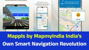
✅ 3. Real-Time Traffic & Road Alerts
Mappls gives live updates on traffic jams, roadblocks, construction, and accidents, helping users plan better and save time.
✅ 4. EV-Friendly Navigation
Mappls shows nearby EV charging stations with real-time availability – a first for Indian maps.
✅ 5. Offline Maps
Maps and directions can be downloaded for offline use, especially useful in rural or low-connectivity zones.
✅ 6. 3D & Video Maps
Users can explore cities in immersive 3D or video map formats, helping with tourism, travel planning, and real estate.
✅ 7. Live Dashcam Integration
The app can connect with car dashcams or phone cameras for live streaming navigation.
Why Mappls is Better than Google Maps in India
| Feature | Mappls | Google Maps |
|---|---|---|
| India-specific accuracy | High (including house numbers) | Moderate |
| Offline maps | Fully functional | Limited |
| Mappls PIN | Yes | No |
| Data privacy | Strong, no ads or data sale | Ad-driven model |
| Made in India | Yes | No |
| Government adoption | High | Low |
Mappls prioritizes privacy, Indian localization, and user control—making it uniquely positioned in India’s tech ecosystem.
Industries Using Mappls
1. E-commerce & Logistics
Mappls is integrated with logistics firms like Flipkart, Amazon, and courier services for route optimization, delivery tracking, and address validation.
2. Automobile Sector
Automakers like Hyundai, Tata, MG, Mahindra, and more are embedding Mappls into their vehicles’ infotainment systems.
3. Government Projects
Used in over 100 smart cities for:
- Traffic monitoring
- Urban planning
- Crime mapping
- Pollution control
- Emergency response
4. Banking & Insurance
Banks use Mappls for address verification, fraud detection, and KYC processes.
Government Support & Smart Cities Integration
Mappls plays a vital role in:
- Smart Cities Mission
- Digital India
- Gati Shakti Scheme
- Drone Mapping Initiatives
MapmyIndia works with ISRO, NIC, MoRTH, and Ministry of Housing & Urban Affairs, offering tools for mapping, navigation, and spatial analytics.
Technologies Behind Mappls
Mappls is powered by:
- Artificial Intelligence (AI): For route prediction, vehicle tracking
- Machine Learning (ML): For traffic flow and behavioral patterns
- Internet of Things (IoT): Vehicle integration, telemetry
- Satellite and Drone Imagery: High-resolution 3D maps
- Cloud Computing: Real-time syncing of data
With over 14 lakh km of road network, 7.5 crore house addresses, and crores of points of interest, Mappls is India’s most comprehensive geospatial database.
Mappls APIs and Developer Tools
MapmyIndia provides 300+ APIs and SDKs to developers. These are used to build:
- Navigation apps
- Route planning software
- EV location services
- Pollution & weather alerts
- Custom GIS solutions
API users include logistics firms, mobility startups, civic planners, and health tech firms.
Privacy and Data Protection
Unlike many global platforms, Mappls:
- Does not sell user data
- Hosts data only in India
- Does not show ads
- Provides 100% user control
- Is compliant with GDPR and Indian data laws
This makes Mappls the most secure mapping service in India.
Challenges Faced by Mappls
While Mappls has made major progress, challenges remain:
- Brand awareness compared to Google Maps
- Habit inertia among users
- Frequent updates needed for accuracy
- Limited adoption internationally
Despite this, rapid growth, government endorsements, and auto-industry integrations are closing the gap fast.
Future Vision and Expansion Plans
MapmyIndia is planning:
- Augmented Reality (AR) navigation
- Global expansion
- Drone delivery mapping
- Village-level mapping
- Integration with 5G smart mobility
- Multilingual voice navigation
Mappls also aims to integrate with India’s Open Network for Digital Commerce (ONDC) and National Geospatial Policy.
Frequently Asked Questions (FAQs)
Q1. Is Mappls free to use?
Yes, it’s completely free for individuals.
Q2. Can Mappls be used offline?
Yes, maps and routes can be used without the internet.
Q3. What is a Mappls PIN?
A 6-character digital address code unique to every location in India.
Q4. How accurate is Mappls?
Very accurate – it supports house number-level navigation across cities and towns.
Q5. Is Mappls available on all devices?
Yes – available for Android, iOS, and web platforms.
Conclusion: Why Mappls is India’s Mapping Future
Mappls is not just an app; it’s a symbol of India’s digital self-reliance, innovation, and future-ready mobility infrastructure. As India evolves into a digitally empowered society, platforms like Mappls offer a secure, scalable, and indigenous solution to mapping, navigation, and urban intelligence.
Whether you’re a daily commuter, delivery agent, civic planner, or EV driver, Mappls brings unmatched precision, features, and confidence in finding your way—powered by India, built for India.